
Culver City has spent years debating bicycles and cars as though every transportation decision has to produce a winner and a loser.
I think we should ask a different question:
What if we could make bicycling safer without forcing bicycles and cars to compete for the same busy streets whenever there is a better alternative nearby?
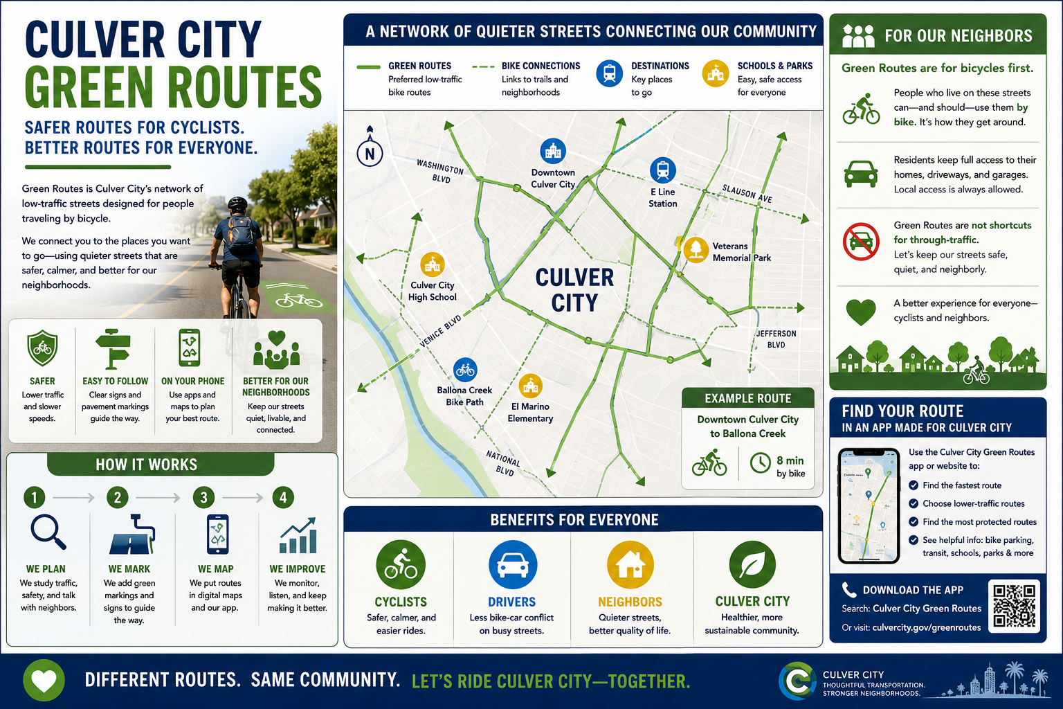
My proposal is something I call Culver City Green Routes: a connected network of lower-traffic neighborhood streets specifically identified as preferred routes for people traveling by bicycle.
Instead of automatically directing cyclists onto the same major streets used by thousands of cars every day, we should identify quieter alternatives whenever they can take cyclists to the same destinations safely and efficiently.
But there is another important part of the idea:
Green Routes should be designed primarily for bicycle through-travel and local neighborhood access—not as shortcuts for additional automobile traffic.
People who live on Green Route streets would, of course, continue to drive to and from their homes. Residents need access. Deliveries need access. Emergency vehicles need access. Visitors and services need access.
The goal is not to eliminate cars from residential streets.
The goal is to avoid intentionally directing unnecessary through automobile traffic onto the same quiet streets we are asking cyclists to use.
The objective is simple:
Safer routes for cyclists. Appropriate access for residents. Major routes for through automobile traffic. Less conflict between everyone.
Not Every Bicycle Trip Needs to Be on a Major Street
Cars generally use major streets because those streets were designed to accommodate significant automobile traffic.
But why should a cyclist necessarily have to use the same street?
Sometimes there is a quieter residential street only one or two blocks away traveling in essentially the same direction.
If that street can provide a safe and continuous bicycle connection, why not make it easy for cyclists to find and use it?
Imagine riding your bicycle across Culver City and seeing a recognizable Green Route marking telling you:
This is a preferred lower-traffic bicycle route. Follow it.
The route could lead toward Downtown Culver City, schools, parks, the E Line station, Ballona Creek, employment areas, neighboring communities, and other important destinations.
Instead of cyclists having to figure out the safest route themselves, Culver City could help create the route for them.
Green Routes Shouldn't Become Automobile Shortcuts
This is critical.
If we designate a quiet residential street as a preferred bicycle route and then navigation applications begin directing thousands of additional cars down that street, we have defeated the purpose.
The street is no longer quiet.
It is less comfortable for cyclists.
And the people who live there suddenly have more traffic in front of their homes.
That's not what I am proposing.
Green Routes should prioritize bicycle through-travel while preserving automobile access for the people who actually need to use those streets.
Residents living along the route still drive home.
Someone visiting a resident can still get there.
A delivery truck can still make a delivery.
A plumber can still reach a customer's house.
Emergency vehicles retain access.
The distinction is between local access and unnecessary through traffic.
If someone is driving across Culver City and a major street provides the appropriate route, navigation systems should generally direct that driver toward the major street rather than using a Green Route neighborhood as a shortcut.
Meanwhile, a cyclist traveling across Culver City could be directed toward the quieter Green Route.
That creates two complementary networks:
Major streets move through automobile traffic.
Green Routes provide lower-traffic alternatives for bicycles while maintaining normal local vehicle access.
The People Who Live There Should Still Be Able to Bike and Drive
The residents of Green Route neighborhoods should never feel as though their street has been taken away from them.
In fact, they should be among the people who benefit most.
Someone who lives on a Green Route can bicycle directly from their home onto the network.
Their children may have a more comfortable route toward school.
Their family may have an easier bicycle connection to a park.
At the same time, they can continue driving to and from their property because local access remains part of the street's purpose.
The idea isn't:
“Cars aren't allowed here.”
It is:
“If you don't need to drive through this neighborhood, there may be a better automobile route. If you're traveling by bicycle, this is one of the routes we have identified for you.”
That's a very different transportation philosophy.
Make the Routes Easy to Recognize
Green Routes should be simple enough that someone can understand the system without studying a complicated transportation map.
Subject to applicable traffic-control and safety standards, the routes could use recognizable pavement markings, bicycle symbols, signs, or other visual indicators.
At important intersections, signs could provide destination information:
Downtown →
E Line Station →
Ballona Creek Bike Path →
Veterans Memorial Park →
We could even include estimated bicycle travel times.
Suddenly, Culver City becomes easier to navigate by bicycle.
Put Green Routes on Our Phones
Most people now navigate with their phones.
Culver City should therefore create an official digital map of its preferred bicycle network and make appropriate transportation information available to navigation and mobility companies.
We could work with Google Maps, Waze, Uber, Lyft, and other technology companies where their platforms support bicycle or multimodal transportation.
But there is an equally important part of that conversation.
We should encourage navigation providers not to unnecessarily route through automobile traffic onto streets that Culver City has identified as Green Routes when appropriate alternatives exist.
Technology could therefore help separate the two transportation functions.
For bicycles:
Prefer the quieter Green Route.
For through automobile trips:
Prefer the appropriate major street.
For someone whose home or destination is on the Green Route:
Provide normal local access.
That's smarter routing.
If Private Companies Won't Do It, Culver City Can Build Its Own
Our transportation strategy should not depend entirely on whether private technology companies decide to participate.
We should approach existing navigation companies first because millions of people already use their products.
But if they don't provide the functionality Culver City needs, the city should explore developing its own Green Routes app or web-based navigation tool.
A cyclist could enter a destination and choose among:
Fastest Route
Lower-Traffic Green Route
Most Protected Route
The city could encourage residents to use the service through schools, parks, community events, city communications, local businesses, transit information, and bicycle programs.
QR codes on Green Route signs could immediately open the map.
Scan.
Choose your destination.
Choose your route.
Ride.
Don't Just Paint Streets Green
A colored line doesn't make a street safe.
Before a street becomes part of the network, Culver City should examine actual conditions, including:
Traffic volume
Vehicle speeds
Collision history
Intersection safety
Visibility
Street width
Existing bicycle infrastructure
Connections to other routes
Access to schools, parks and transit
The needs of residents living along the proposed route
And this last point is important.
The people living on a proposed Green Route should be part of the planning process.
They understand their streets.
They know where cars speed.
They know which intersections are difficult.
They know where children cross.
They know where visibility is poor.
Transportation planning should use that knowledge.
Protect Green Route Neighborhoods From Cut-Through Traffic
Culver City should also measure what happens to automobile traffic after a Green Route is established.
If a street begins attracting substantial cut-through traffic, the city should investigate why.
Possible solutions could include traffic-calming measures, intersection changes, signage, navigation-data corrections, or other appropriate tools.
The objective should not be to make residents' lives difficult.
It should be to preserve the character that made the street attractive as a bicycle route in the first place:
lower speeds and lower traffic volumes.
Start With a Pilot
Rather than redesigning the entire city at once, let's test the concept.
Choose several destinations such as Downtown Culver City, the E Line station, schools, parks, and Ballona Creek.
Identify lower-traffic streets that could connect them.
Talk to the residents who live along those routes.
Measure existing traffic.
Measure speeds.
Study collisions and intersections.
Create a pilot Green Route.
Put it on a digital map.
Then measure what happens.
Did bicycle use increase?
Do cyclists feel more comfortable?
Did automobile traffic increase or decrease?
Did cut-through traffic develop?
What do the residents living along the route think?
Are there dangerous intersections that need improvement?
How much did the project cost?
Then make decisions based on the evidence.
A Better Way to Think About Our Streets
The central idea behind Green Routes isn't really about green paint.
It is about routing different forms of transportation intelligently.
Imagine Culver City as two overlapping networks.
Through Automobile Network
Major streets handle much of the traffic traveling across the city.
Green Bicycle Network
Lower-traffic streets provide alternative routes for cyclists.
Local Neighborhood Access
Residents, visitors, deliveries, services, and others who actually have destinations inside Green Route neighborhoods retain normal access.
Instead of forcing every transportation mode onto exactly the same streets, we use different streets for the purposes they perform best whenever practical.
This Isn't Cars Versus Bikes
Most Culver City residents aren't exclusively drivers or cyclists.
The same person may drive to work, bicycle on the weekend, walk to a restaurant, and take the E Line another day.
Transportation planning should recognize that reality.
I don't want transportation policy designed to punish drivers.
I don't want transportation policy designed to discourage cyclists.
And I don't want a bicycle program that makes life unnecessarily difficult for residents who happen to live along a designated route.
I want transportation designed around how people actually move.
When bicycles and cars need to share a street, let's make it safer.
When they don't need to use the same street, let's give them different options.
And when someone lives on a Green Route, let's make sure they can continue getting to and from their home normally.
My Proposal
As a member of the Culver City Council, I would advocate exploring a Culver City Green Routes pilot program based on these principles:
Identify lower-traffic streets capable of creating a connected bicycle network.
Prioritize Green Routes for bicycle through-travel while maintaining local automobile access for residents, visitors, deliveries, services, and emergencies.
Avoid intentionally directing unnecessary through automobile traffic onto Green Routes when appropriate major-street alternatives exist.
Involve residents living along proposed Green Routes before implementation.
Create recognizable route markings and signs consistent with applicable safety standards.
Connect important destinations including schools, parks, Downtown Culver City, transit, Ballona Creek, businesses, and employment areas.
Publish the network digitally so residents can access it from their phones.
Work with navigation and mobility companies to improve bicycle routing and, where possible, reduce unnecessary automobile cut-through traffic on designated Green Routes.
Develop a Culver City Green Routes app or web-based navigation system if private companies don't provide the functionality we need.
Encourage Culver City residents to use the system through schools, parks, community programs, QR codes, local businesses, and city communications.
Analyze real safety conditions before designating streets.
Improve dangerous intersections and missing connections instead of assuming paint alone creates safety.
Monitor automobile traffic on Green Routes to ensure the program isn't creating new cut-through traffic problems for residents.
Measure the pilot's results before substantially expanding the program.
Safer Routes Without Turning Neighborhoods Upside Down
We don't have to choose between bicycle safety and functioning neighborhoods.
We can design for both.
Let major streets carry much of the automobile traffic traveling across Culver City.
Let quieter streets provide attractive alternatives for bicycles where appropriate.
Let the people who live on those streets continue using their cars because they actually need access to their homes.
And use technology to help everyone find the route that makes the most sense for how they are traveling.
Don't unnecessarily send bicycles into heavy traffic.
Don't unnecessarily send through automobile traffic into quiet neighborhoods.
And don't make it difficult for residents to reach their own homes.
That's the philosophy behind Culver City Green Routes: safer routes for cyclists, appropriate access for neighbors, better routes for drivers, and smarter transportation for Culver City.
0 Comments
Comments are reviewed before they appear.